- Delivered as EPS & JPG
- High-quality downloads
- Over 30 years of experience
✅ Diverse formaten
✅ Niet goed, geld terug
✅ Meer dan 30 jaar ervaring
Kaart op maat
Klantenservice
Over Kaarten en Atlassen
Algemeen
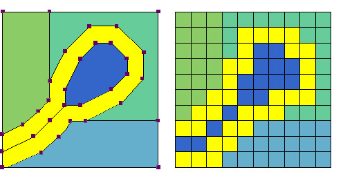
These are two terms that regularly come up in the world of map production. It is understandable if they are not immediately familiar, as the difference between raster and vector maps is not always obvious. In this article, both concepts are explained in a clear and accessible way. So where to begin? What sets these two types of maps apart? Let’s start with the one most people already recognise.
A photograph or image viewed on a screen such as a JPEG is almost always made up of pixels. These are the small blocks that become visible when an image is enlarged. As you zoom in further, individual pixels appear more clearly. This occurs because a photograph is a raster-based file, which is defined by its pixel structure.


Advantages and disadvantages
Raster and vector formats each have their own characteristics. Some are more practical or accessible depending on how the map is used. One of the main strengths of raster format is its widespread compatibility. Raster images are the standard for photographs, illustrations, maps and icons — essentially most visual content. All computers, mobile devices, digital displays and other media platforms can handle this format without issue.
When a raster image is printed, the pixel structure is still present, even if it is not immediately visible. This accessibility explains why raster is the most commonly used format. However, there is one area where raster falls short compared to vector, and that is image quality.
To address this directly, the key advantage of vector over raster lies in quality preservation. Raster files cannot be stretched, scaled, rotated or enlarged without loss of clarity. Vector graphics, on the other hand, are built from points, lines and shapes rather than pixels. This structural difference sets vector apart from raster-based images. While this means vector is less suited for photographic content, it excels in fields where precision and scalability are essential. In the domain of maps and atlases, vector formats offer clear advantages, making them the preferred choice for detailed and flexible cartographic work.


Working with vector formats is therefore essential for maintaining the quality of geographic material. Vectors offer flexibility and can be adapted into different forms with ease, something raster files struggle with. Individual data elements can even be incorporated into specific parts of a vector file, which is where the real potential begins to emerge.
Exploring those possibilities in greater depth is best left for a future article. For now, this overview should provide a clearer understanding of how raster and vector formats differ, along with their respective strengths and limitations.

Do you have any questions? Feel free to contact us!
Ontvangt u toch liever advies voordat u een keuze maakt? Dat kan!